| | | Number of channels | 1598 | |
| | BDS |
B1I,B2I,B3I, B1I,B3I,B1C,B2a,B2b
| |
| | GPS | L1C/A,L2P,L2C,L5,L1C* | |
| | GLONASS | G1,G2,G3* | |
| | GALILEO | E1,E5b,E5a,E5 AltBoc*,E6c* | |
| | QZSS | L1 ,L2C, L5/ IRNSS:L5*/ SBAS:L1C/A,L5* | |
| | Positioning output rate | 1Hz~20Hz | |
| | Differential support | CMR,RTCM2.X,RTCM3.0,RTCM3.2 | |
| | Static format support | GNS, Rinex dual format static data | |
| | RTK positioning accuracy | Plane: ±(8+1×10⁻⁶D) mm (D is the distance between the measured points) Elevation: ±(15+1×10⁻⁶D) mm
(D is the distance between the measured points) | |
| | Static positioning accuracy | Plane: ±(2.5+0.5×10¯6D) mm (D is the distance between the measured points)
Elevation: ±(5+0.5×10¯6D) mm
(D is the distance between the measured points) | |
| | DGPS positioning accuracy | Plane accuracy: ±0.25m+1ppm;Elevation accuracy: ±0.50m+1ppm | |
| | Initialization time | <10 seconds | |
| | Initialization reliability | >99.99% | |
| | IMU tilt compensation | Additional horizontal pole tip uncertainty typically less than 10mm + 0.7 mm/° tilt down to 30°
IMU tilt angle:0°~60° | |
| | | NFC wireless communication | Adopting NFC wireless communication technology, the manual can automatically pair with the host by touching it (the manual
alsoneeds to be equipped with an NFC wireless communication module) | |
| | WiFi | 802.11b/g access point and client mode, can provide WiFi hotspot service | |
| | Bluetooth | BLEBluetooth 4.0 standard, support for android, ios cellphone connection | |
| | Wireless modem | Built-in radio, typically work range can be 8KM Radio repeater | |
| | I/O port | 5PIN LEMO external power port + RS232, 1 radio antenna interface, Type C , Micro SIM card | |
| | frequency band: | 410-470MHz | |
| | Protocol | SOUTH,Farlink,TrimTalk,ZHD, HUACE | |
| | | Buttons | Power key | |
| | Indicators | Three indicator lights+Battery display light (at the bottom of the instrument): data light, Bluetooth light, power light (button
position) | |
| | Electrical physical properties | battery | Internal Li-on, 6800mAh, 7.4V | |
| | Power Supply | 9-25V DC, overvoltage protection | |
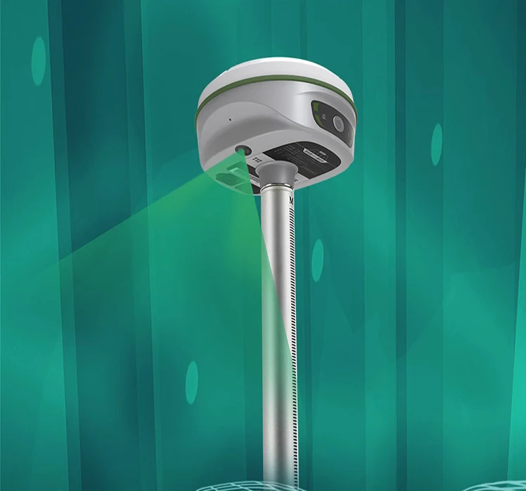
| | size | 135mm(Diameter)x84.75mm(Height) | |
| | weight | 0.89kg (battery included) | |
| | material | Magnesium aluminum alloy shell | |
| | Environmental characteristics | Dust and water release | IP68 standard, protected from long time immersion to depth of 1m | |
| | Storag | -55°C~+85°C | |
| | Operating | -45℃~75℃ | |
| | | | Built in temperature sensor, using intelligent variable frequency temperature control technology to monitor and adjust the
hosttemperature in real-time | |
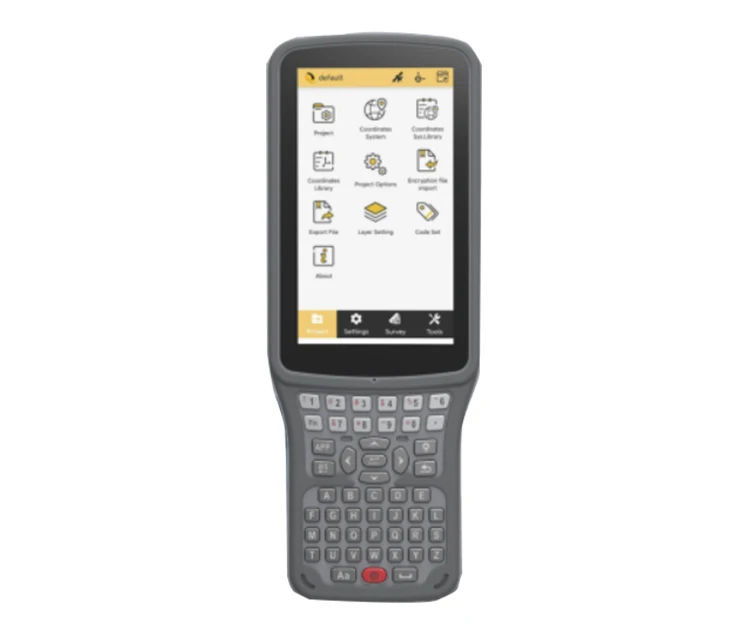
| | | model | H6 | |
| | operating system | Linux | |
| | CPU | 2.0 GHz eight-core processor | |
| | Memory | 3GB RAM | |
| | Storage | 32GB | |
| | | Network | TDD/FDD-LTE 4G | |
| | WiFi | 802.11b/g access point and client mode, can provide WiFi hotspot service | |
| | Bluetooth | BT4.2(BR/EDR+BLE) | |
| | NFC | Support NFC IGRS | |
| | USB | Mini USB, supports OTG | |
| | | Battery | 7.4V, 3400mAh | |
| | Battery life | 12 hours | |
| | Charging | < 4 hrs for full charge | |
| | | size | 131mm*80mm | |
| | Weight | 800g | |
| | Operating temperature | -35℃ ~ +80℃ | |
| | Voice | IVoice intelligent voice technology, intelligent status reporting, voice operation prompts; Chinese, English, Korean, Russian,
Portuguese, Spanish and Turkish are supported by default; Support for voice customization | |
| | Data storage/transmission | | Built-in 4GB solid-state storage, rich sampling intervals, and support for raw observation data collection up to 20Hz | |
| | data transmission | Supports data transmission such as USB, FTP download, HTTP, etc | |
| | | Static data formats: various formats such as Southern STH, Rinex2.01, and Rinex3.02 Differential data format: RTCM3.0, RTCM3.2
input and output GPS output data format: NMEA 0183, PJK plane coordinates, binary code Network mode support: VRS, FKP, MAC,
support for NTRIP protocol | |