Sign In | Join Free | My disqueenfrance.com
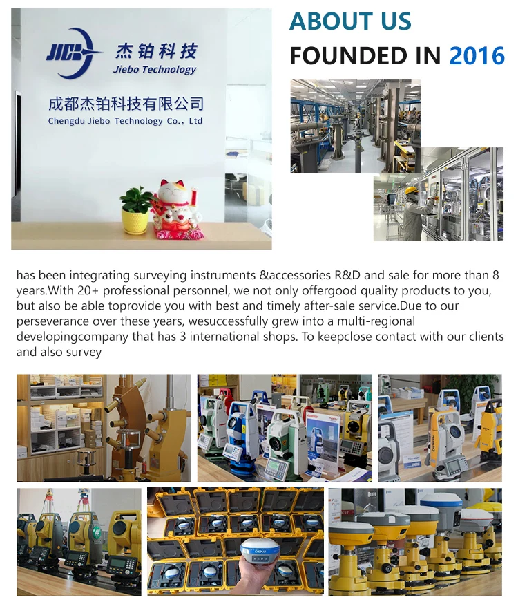
China Chengdu Jiebo Technology Co., Ltd. logo
Chengdu Jiebo Technology Co., Ltd.
CHENGDU JIEBO TECHNOLOGY CO.,LTD Main categories: GPS measuring instrument,total station,Level,Theodolite,Measuring accessories
Verified Supplier

1 Years

Home > GNSS RTK Receiver >

Bluetooth CHCNAV M11 PRO/I93 Geodetic Gnss Receiver Visual RTK Rover DGPS Surveying Instrument

Chengdu Jiebo Technology Co., Ltd.
Trust Seal
Verified Supplier
Credit Check
Supplier Assessment
Contact Now

Bluetooth CHCNAV M11 PRO/I93 Geodetic Gnss Receiver Visual RTK Rover DGPS Surveying Instrument

Brand Name : CHCNAV

Model Number : X11 PRO

Place of Origin : China

MOQ : 1 piece

Price : $5,550.00

Payment Terms : L/C, T/T

Supply Ability : 1 ~ 30 day

Delivery Time : 30 work day

Product name : RTK receiver

Material : magnesium alloy

Operating Language : English

Application : Land Surveying

Channels : 1408

Customized support : OEM, ODM, OBM

GPS : L1c/a, l1c, l2c, l2e, l5

Glonass : G1/G2/G3

Galileos : E1, E5A, E5B, E5AltBOC, E6

QZSS : L1C/A,L1C,L2C,L5

Transmitting speed : 9.6Kbps, 19.2Kbps

Contact Now

CHC CHCNAV M11 PRO/I93 Gnss Visual Rtk Rover GPS Receiver DGPS Surveying Instrument with 3D Modeling

Product Description
High Accuracy Land Surveying Instrument CHCNAV X16 Pro/i93 GPS RTK for Excellent Visual Stakeout and Best Price GPS RTK
X16Pro RTK is a new product that integrates CHC video photogrammetry technology, supporting video measurement and 3D modeling. It quickly and efficiently obtains high-precision 3D coordinates in batches from live videos, achieving what you see is what you measure, and can be measured while walking. Support AR real scene navigation and immersive real scene 3D modeling, with no getting lost and one shot in place, improving efficiency by 50%. Upgraded the anti daze design of the center pole, combined with following the lofting, the lofting base map rotates with people, and the navigation is viewed from the first perspective, without the need to struggle to identify direction and distance. Upgraded Huace Yizhang Network ™ The same origin 2.0 algorithm as the cloud has increased the fixed rate to 96%. Support non-invasive super inertial navigation, no initialization required, point to point measurement, and reliable accuracy. At the same time, it supports satellite based differential and continuous testing without network, and can be tested with or without network.
Product Details
GNSS Performance
Channels
1408 channels
GPS
L1C, A, L2C, L2P(Y), L5
GLONASS
L1, L2, L3
Galileo
E1, E5a, E5b, E6*
BeiDou
B1I, B2I, B3I, B1C, B2a, B2b
QZSS
L1, L2, L5, L6*
PPP
B2b-PPP
SBAS (EGNOS Support)
L1, L5
GNSS Accuracies
Real time kinematic (RTK)
H: 8 mm + 1 ppm RMS V: 15 mm + 1 ppm RMS
Initialization time: < 10s

Initialization time: 99.9%
Post-processing kinematic (PPK)
H: 3 mm + 1 ppm RMS V: 5 mm + 1 ppm RMS
Post-processing static
H: 2.5 mm + 0.5 ppm RMS V: 5 mm + 0.5 ppm RMS
Code differential
H: 0.4 m RMS | V: 0.8 m RMS
Autonomous
H:1.5 m RMS | V: 2.5 m RMS
Visual survey
Typical 2~4 cm, range 2~15 m
Positioning rate
1 Hz, 5 Hz and 10 Hz
Time to first fix
Cold start: < 45 s, Hot start: < 10 s Signal re-acquisition: < 1 s
IMU update rate
200Hz
Till angle
0-60°
RTK tilt-compensated
Additional horizontal pole-tilt uncertainty typically less than 10 mm + 0.7 mm/° tilt
Environments
Temperature
Operating: -40°C to +65°C (-40°F to +149°F)Storage: -40°C to +85°C (-40°F to +185°F)
Humidity
100% non-condensation
Ingress protection
IP67 (according to IEC 60529)
Drop
Survive a 2-meter pole-drop
Vibration
Compliant with ISO 9022-36-08 and MIL-STD-810G- 514.6-Cat.24.
Waterproof and breathable membrane
Prevent water vapor from entering under harsh environments
Electrical
Power consumption
UHF/ 4G RTK Rover w/o camera: Typical 2.8 W Visual Stakeout/Visual Survey: Typical 4 W
Li-ion battery capacity
Built-in non-removable battery 9,600 mAh, 7.4 V
Operating time on internal battery
UHF/ 4G RTK Rover w/o camera: up to 34 h Visual Stakeout/Visual Survey: up to 24 h
UHF RTK Base: up to 16 h Static: up to 36 h
External power input
9 V DC to 28 V DC
Hardware
Size (D x H)
Φ 152 x 81 mm (Φ 5.98 x 3.19 in)
Weight
1.15 kg (2.54 lb)
Front panel
1.1'' OLED Color Display 2 LED, 2 physical buttons
Tilt sensor
Calibration-free IMU for pole-tilt compensation. Immune to magnetic disturbances. E-Bubble leveling.
Cameras
Sensor pixels
Global shutter with 2 MP & 5 MP
Field of view
75°
Video frame rate
25 fps
Image group capture
Method: video photogrammetry. Rate: typically 2 Hz, up to 25Hz.
Max. capture time: 60s with an image group size of appr. 60MB.
lllumination
Starlight-grade camera. OmniPixel®-GS technology.
Maintain full color at illumination levels as low as 0.01 lux.
Communication
SIM card type
Nano-SIM card
Network modem
Integrated 4G modem: TDD-LTE, FDD-LTE, WCDMA, EDGE, GPRS, GSM
Wireless connection
NFC for device touch pairing
Wi-Fi
Wi-Fi IEEE 802.11a/b/g/n/ac, access point mode
Bluetooth®
5.0 and 4.2 +EDR, backward compatible
Ports
1 x 7-pin LEMO port (RS-232) 1 x USB Type-C port (external power, data download, firmware update)
1 x UHF antenna port (TNC female)
Built-in UHF radio
Rx/Tx: 410 - 470 MHz Transmit Power: 0.5 W to 2 W
Protocol: CHC, Transparent, TT450,
Satel Link rate: 9 600 bps to 19 200 bps
Range: Typical 3 km to 5 km, up to 15 km with optimal conditions
Data formats
RTCM 2.x, RTCM 3.x, CMR input / output HCN, HRC, RINEX 2.11, 3.02 NMEA 0183 output
NTRIP Client, NTRIP Caster
Data storage
8 GB internal memory. Support 128 GB external expansion
Compliance with Laws and Regulations
International standards
NGS Antenna Calibration, IEC 62133-2:2017+A1, IEC 62368- 1:2014, UN Manual Section 38.3

Certifications

Bluetooth CHCNAV M11 PRO/I93 Geodetic Gnss Receiver Visual RTK Rover DGPS Surveying Instrument
Company Profile
Bluetooth CHCNAV M11 PRO/I93 Geodetic Gnss Receiver Visual RTK Rover DGPS Surveying Instrument

FAQ

1. who are we?
We are based in sichuan, China, start from 2016,sell to Africa(30.00%),Southeast Asia(16.00%),Mid East(11.00%),Eastern
Asia(10.00%),South America(10.00%),Central America(5.00%),South Asia(5.00%),Southern Europe(5.00%),North America(4.00%),Eastern
Europe(4.00%). There are total about 11-20 people in our office.

2. how can we guarantee quality?
Always a pre-production sample before mass production;
Always final Inspection before shipment;

3.what can you buy from us?
GNSS RTK,Total station,Level,Survey accessory,laser rangefinder

4. why should you buy from us not from other suppliers?
1.More than 20 years of experience in the trade field. 2.All products will have been strictly quality checked in factory before
sending out and all products have one year warranty.

5. what services can we provide?
Accepted Delivery Terms: FOB,CFR,CIF,EXW,FAS,CIP,FCA,CPT,DEQ,DDP,DDU,Express Delivery,DAF,DES;
Accepted Payment Currency:USD,EUR,JPY,CAD,AUD,HKD,GBP,CNY,CHF;
Accepted Payment Type: T/T,L/C,D/P D/A,MoneyGram,Credit Card,PayPal,Western Union,Cash,Escrow;
Language Spoken:English,Chinese,Spanish,Japanese,Portuguese,German,Arabic,French,Russian,Korean,Hindi,Italian

Our Service
Bluetooth CHCNAV M11 PRO/I93 Geodetic Gnss Receiver Visual RTK Rover DGPS Surveying Instrument
Packing & Delivery
Bluetooth CHCNAV M11 PRO/I93 Geodetic Gnss Receiver Visual RTK Rover DGPS Surveying Instrument


Product Tags:

CHCNAV geodetic gnss receiver


geodetic gnss receiver RTK Rover


M11 rtk bluetooth

      
China Bluetooth CHCNAV M11 PRO/I93 Geodetic Gnss Receiver Visual RTK Rover DGPS Surveying Instrument wholesale

Bluetooth CHCNAV M11 PRO/I93 Geodetic Gnss Receiver Visual RTK Rover DGPS Surveying Instrument Images

Inquiry Cart 0
Send your message to this supplier
 
*From:
*To: Chengdu Jiebo Technology Co., Ltd.
*Subject:
*Message:
Characters Remaining: (0/3000)
 
Inquiry Cart 0